


VTT(74)-Giffre

HG74250
User
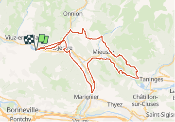

Length
40 km

Max alt
935 m

Uphill gradient
1535 m
Km-Effort
61 km

Min alt
477 m

Downhill gradient
1527 m
Boucle
Yes
Creation date :
2019-01-15 15:33:53.886
Updated on :
2020-01-04 17:34:01.04
3h51
Difficulty : Difficult

FREE GPS app for hiking
 SityTrail
IGN / Geographical institutes
SityTrail Plus
The world is yours!
About
Trail Mountain bike of 40 km to be discovered at Auvergne-Rhône-Alpes, Upper Savoy, La Tour. This trail is proposed by HG74250.
Positioning
Country:
France
Region :
Auvergne-Rhône-Alpes
Department/Province :
Upper Savoy
Municipality :
La Tour
Location:
Unknown
Start:(Dec)
Start:(UTM)
301373 ; 5112393 (32T) N.
Comments